Friday 17 October 2014

Om Parvat

Om Parvat (also Adi Kailash, Little Kailash, Jonglingkong Peak, Baba Kailash, chhota Kailash)[3] is a mountain in the Himalayan mountain range, lying in the Darchula district of western Nepal and in Pithoragarh District, Uttarakhand, India. It is considered sacred by Hindus and its snow deposition pattern resembles the sacred 'OM' (ॐ). Its appearance is distinctly similar to Mount Kailash in Tibet.[4] Near Om Parvat lie Parvati Lake and Jonglingkong Lake. Jonglingkong Lake is sacred, as Mansarovar, to the Hindus. Opposite to this peak is a mountain called Parwati Muhar. The Om Parvat is the fruit of discord between India and Nepal who do not reach agreement about the border line between the two countries. The Om Parvat is currently on the Indo-Nepalese border face "Om/ॐ" in India and the back of the mountain in Nepal.

Overview

This peak was attempted for the first time by an Indo-British team including Martin Moran, T. Rankin, M. Singh, S. Ward, A. Williams and R. Ausden. The climbers promised not to ascend the final 10 metres (30 ft) out of respect for the peak's holy status. However, they were stopped around 200 m (660 ft) short of the summit by very loose snow and rock conditions.[4]
The first ascent of Adi Kailash came on October 8, 2004. The team comprised Tim Woodward, Jack Pearse, Andy Perkins (UK); Jason Hubert, Martin Welch, Diarmid Hearns, Amanda George (Scotland); and Paul Zuchowski (USA). They did not ascend the final few metres, again out of respect for the sacred nature of the summit.[2]
Om Parvat can be viewed en route to the Kailash Manasarovar Yatra from the last camp below Lipu Lekh pass at Nabhidhang. Many trekkers to Adi Kailash often make a diversion to view Om Parvat. Om Parvat and Adi Kailash or Baba Kailash are not one and the same. Om Parvat is located near Nabhi Dhang (Nepal),The Chhota Kailash is located near Sinla pass, Near Brahma Parvat.
The best view of Om Parvat which "Om" drawn by the snow is the view from the district of Pithoragarh (Uttarakhand, India), which faces the mountain and hence to the "Om".

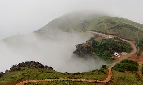
Mullayyanagiri

Mullaiahnagiri (Kannada: ಮುಳ್ಳಯ್ಯನಗಿರಿ) (also spelt Mullayangiri or Mullaiyanagiri) is the highest peak in Karnataka, India. Mullaiahnagiri is located at 13°23′26″N 75°43′18″E in the Chandra Dhrona Hill Ranges of the Western Ghats of Chikmagalur Taluk. With a height of 1,930 metres (6,330 ft), it is the highest peak between the Himalayas and the Nilgiris. Mullaiahnagiri is one of the best trekking places in Karnataka and South India. The Sunset presents a spectacular view from the peak.

Mullayanagiri (also spelt as Mullayyanagiri or Mullayangiri) is the highest peak of Karnataka state located in Bababudangiri range of Chikmagalur.
Mullayanagiri is just 12 Km from Chikmagalaur. Mullayanagiri is part of the Baba Budan Giri Hill Ranges. The height of Mullayanagiri is 6330 ft (1,930 meters) and it is regarded as the highest peak between Himalayas and Nilgiris.

There is a small temple dedicated to Lord Shiva on top of the hill. The small hillock in the temple premises is the highest point in Karnataka.

Mullayanagiri is the trekker's paradise. Trekking at this place is a memorable experience. You can enjoy the speed of cold wind that is hitting you. It will be a good experience if you reach this place by 7 AM.

Baingan bharta

Baingan bharta or Baingan ka bhurtha or Baingan da bhurtha or Wangyacha Bharit (Hindi: बैंगन भरता, Urdu: بینگن کا بھرتہ ‎, Marathi: वांग्याचं भरीत) (Mashed Eggplant) is a South Asian dish bearing a resemblance to baba ghanoush. Baingan bharta is a part of the national cuisines of both India and Pakistan. It is primarily a vegetarian dish that comprises bhurtha (minced vegetables) made from eggplant (baingan) which is grilled over charcoal or direct fire, to infuse the dish with a smoky flavour. The smoked eggplant is mashed with fresh cilantro (coriander leaves), chili pepper, onion and mustard oil.[1] Traditionally, the dish is often eaten with an Indian flatbread (specifically roti or paratha) and is also served with rice and/or raita, a yogurt salad. Baingan bartha is also eaten in Bangladesh.
In Pakistan, baingan bharta is popular cuisine, while in India it is also a part of the cuisines of Maharashtra, Bihar, Orissa, and West Bengal. The dish has many names depending on the local language (Hindi: "बैंगन का भरता", Gujarati: "odo", Bengali: বেগুন ভর্তা "begun bhôrta", Marathi: "Wangyacha bharit").

Variants

In the South Indian state of Tamil Nadu, the Tamils prepare a similar dish called "kathrikai thayir kothsu", in which the eggplant is cooked, mashed and sautéed with mustard, red chilis and sesame oil. The final step in the recipe involves adding curd to the mixture and dressing the dish with coriander leaves.
In the Bhoj-Puri speaking region such as the eastern part of Uttar Pradesh and west Bihar it is known as Baigan ka chokha, it also popular within the Caribbean Indo-Community such as Trinadad, Suriname and Guyana where descendants of indentured labourers from Northern India live.
Eggplant is popular in Afghanistan in the form of a traditional salad called "bonjan salad", which is usually served at room temperature (or cold) together with main dishes. The "bonjan salad" dish is served with a variety of breads and is similar to another Afghani dish called "baingan ka raita" (Urdu: بینگن کا رائتہ ‎).
In Maharashtra, especially in northern parts known as Khandesh, "Vangyache Bharit" as they call it is served in social gatherings including wedding ceremonies. During harvest season, special "Bharit Party" is organised. Baharit is usually served with "Puri". In Vidarbha and Khandesh regions of Maharashtra, two variants are popular "kachha (raw) bharit" and "phodni cha (with tadka) bharit". In kachha bharit, all the ingredients except eggplant are used raw (uncooked). Raw spring onion, tomato, green chillies, green coriander and some times fresh fenugreek leaves are mixed with flame roasted eggplant along with raw Linseed oil or peanut oil. In "phodni cha bharit", above ingredients are first fried in oil with spices and then mashed eggplants are mixed in it and cooked together. The similar process is followed in other Indian states and Pakistan with slight variations on ingredients. In Vidarbha and Khandesh, it is considered a delicacy when eggplants are roasted on a dried cotton plant stems which gives a distinct smokey flavour to the dish. The dish is served with dal, bhakri and rice.

Solar energy

Solar energy is radiant light and heat from the sun harnessed using a range of ever-evolving technologies such as solar heating, solar photovoltaics, solar thermal electricity, solar architecture and artificial photosynthesis.[1][2]
Solar technologies are broadly characterized as either passive solar or active solar depending on the way they capture, convert and distribute solar energy. Active solar techniques include the use of photovoltaic panels and solar thermal collectors to harness the energy. Passive solar techniques include orienting a building to the Sun, selecting materials with favorable thermal mass or light dispersing properties, and designing spaces that naturally circulate air.
In 2011, the International Energy Agency said that "the development of affordable, inexhaustible and clean solar energy technologies will have huge longer-term benefits. It will increase countries’ energy security through reliance on an indigenous, inexhaustible and mostly import-independent resource, enhance sustainability, reduce pollution, lower the costs of mitigating climate change, and keep fossil fuel prices lower than otherwise. These advantages are global. Hence the additional costs of the incentives for early deployment should be considered learning investments; they must be wisely spent and need to be widely
The Earth receives 174 petawatts (PW) of incoming solar radiation (insolation) at the upper atmosphere.[3] Approximately 30% is reflected back to space while the rest is absorbed by clouds, oceans and land masses. The spectrum of solar light at the Earth's surface is mostly spread across the visible and near-infrared ranges with a small part in the near-ultraviolet.[4]
Earth's land surface, oceans and atmosphere absorb solar radiation, and this raises their temperature. Warm air containing evaporated water from the oceans rises, causing atmospheric circulation or convection. When the air reaches a high altitude, where the temperature is low, water vapor condenses into clouds, which rain onto the Earth's surface, completing the water cycle. The latent heat of water condensation amplifies convection, producing atmospheric phenomena such as wind, cyclones and anti-cyclones.[5] Sunlight absorbed by the oceans and land masses keeps the surface at an average temperature of 14 °C.[6] By photosynthesis green plants convert solar energy into chemical energy, which produces food, wood and the biomass from which fossil fuels are derived.[7]


Ebola virus disease


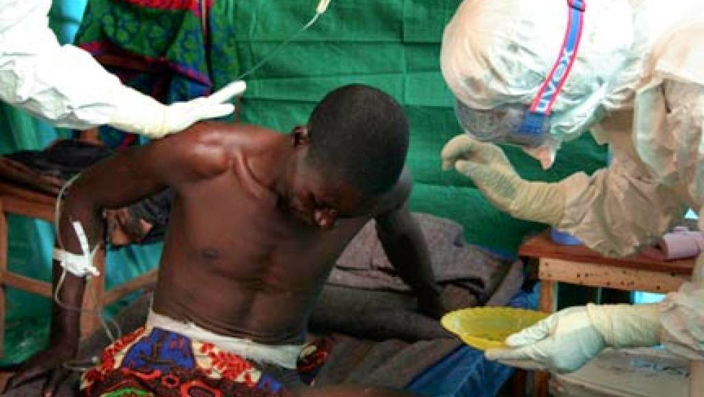
Ebola virus disease (EVD), Ebola hemorrhagic fever (EHF) or simply Ebola is a disease of humans and other mammals caused by an ebolavirus. Signs and symptoms typically start between 2 days and 3 weeks after contracting the virus, with a fever, sore throat, muscle pain and headaches. Then, vomiting, diarrhea and rash usually follows, along with decreased function of the liver and kidneys. Around this time, infected people may begin to bleed both within the body and externally.[1] Death, if it occurs, is typically 6 to 16 days from the start of symptoms and is often due to low blood pressure from fluid loss.[2]
The virus may be acquired upon contact with blood or other body fluids of an infected human or other animal.[1] Spread through the air has not been documented in the natural environment.[3] Fruit bats are believed to be the normal carrier in nature, able to spread the virus without being affected. Humans become infected by contact with the bats or a living or dead animal that have been infected by bats. Once human infection occurs, the disease may spread between people as well. Male survivors may be able to transmit the disease via semen for nearly two months. To diagnose EVD, other diseases with similar symptoms such as malaria, cholera and other viral hemorrhagic fevers are first excluded. Blood samples are tested for viral antibodies, viral RNA, or the virus itself to confirm the diagnosis.[1]
Outbreak control requires a coordinated series of medical services, along with a certain level of community engagement. The necessary medical services include rapid detection and contact tracing, quick access to appropriate laboratory services, proper management of those who are infected, and proper disposal of the dead through cremation or burial.[1][4] Prevention includes decreasing the spread of disease from infected animals to humans.[1] This may be done by only handling potentially infected bush meat while wearing proper protective clothing and by thoroughly cooking it before consumption.[1] It also includes wearing proper protective clothing and washing hands when around a person with the disease.[1] Samples of body fluids and tissues from people with the disease should be handled with special caution.[1]
No specific treatment for the disease is yet available. Efforts to help those who are infected are supportive and include giving either oral rehydration therapy (slightly sweet and salty water to drink) or intravenous fluids. This supportive care improves outcomes. The disease has a high risk of death, killing between 25% and 90% of those infected with the virus (average is 50%). EVD was first identified in an area of Sudan (now part of South Sudan), as well as in Zaire (now the Democratic Republic of the Congo). The disease typically occurs in outbreaks in tropical regions of sub-Saharan Africa.[1] From 1976 (when it was first identified) through 2013, the World Health Organization reported a total of 1,716 cases.[1][5] The largest outbreak to date is the ongoing 2014 West African Ebola outbreak, which is currently affecting Guinea, Sierra Leone, and Liberia.[6][7] As of 15 October 2014, 8,998 suspected cases resulting in the deaths of 4,493 have been reported.[8][9] Efforts are under way to develop a vaccine; however, none yet exists.

Wednesday 15 October 2014

Mehrangarh Fort

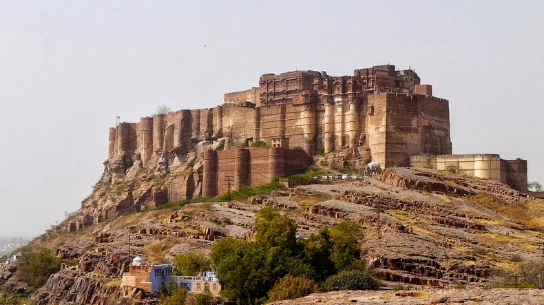
Mehrangarh Fort (Hindi: मेहरानगढ़ का किला), located in Jodhpur, Rajasthan, is one of the largest forts in India.
The fort is situated 400 feet (122 m) above the city and is enclosed by imposing thick walls. Inside its boundaries there are several palaces known for their intricate carvings and expansive courtyards. A winding road leads to and from the city below. The imprints of cannonball hits by attacking armies of Jaipur can still be seen on the second gate. To the left of the fort is the chhatri of Kirat Singh Soda, a soldier who fell on the spot defending the Mehrangarh fort.
There are seven gates, which include Jayapol (meaning 'victory'), built by Maharaja Man Singh to commemorate his victories over Jaipur and Bikaner armies. Fattehpol (also meaning 'victory') gate was built by Maharaja Ajit Singh to mark the defeat of the Mughals. The palm imprints upon these still attract much attention even today.
The museum in the Mehrangarh fort is one of the most well-stocked museums in Rajasthan. In one section of the fort museum there is a selection of old royal palanquins, including the elaborate domed gilt Mahadol palanquin which was won in a battle from the Governor of Gujarat in 1730. The museum exhibits the heritage of the Rathores in arms, costumes, paintings and decorated period rooms.

History of Mehrangarh

Rao Jodha one of Ranmal's 24 sons became the fifteenth Rathore ruler. One year after his accession to the throne, Jodha decided to move his capital to the safer location of Jodhpur, as the one thousand years old Mandore fort was no longer considered to provide sufficient security.
With the trusted aid of Rao Nara (son of Rao Samra), the Mewar forces were subdued at Mandore. With that, Rao Jodha gave Rao Nara the title of Diwan. With the help of Rao Nara, the foundation of the fort was laid on May 12, 1459[1] by Jodha on a rocky hill 9 kilometres (5.6 mi) to the south of Mandore. This hill was known as Bhaurcheeria, the mountain of birds. According to legend to build the fort he had to displace the hill's sole human occupant, a hermit called Cheeria Nathji, the lord of birds. Upset at being forced to move Cheeria Nathji cursed Rao Jodha with "Jodha! May your citadel ever suffer a scarcity of water!". Rao Jodha managed to appease the hermit by building a house and a temple in the fort very near the cave the hermit had used for meditation, though only to the extent that even today the area is plagued by a drought every 3 to 4 years. Jodha then took an extreme measure to ensure that the new site proved propitious; he buried a man called "Raja Ram Meghwal" alive in the foundations. "Raja Ram Meghwal" was promised that in return his family would be looked after by the Rathores. To this day his descendants still live in Raj Bagh, "Raja Ram Meghwal's" Garden, an estate bequeathed them by Jodha.

Tomb of I'timād-ud-Daulah

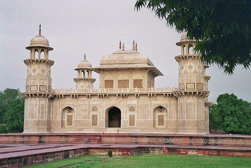
Tomb of I'timād-ud-Daulah (Urdu: اعتماد الدولہ کا مقبرہ‎, I'timād-ud-Daulah kā Maqbara) is a Mughal mausoleum in the city of Agra in the Indian state of Uttar Pradesh. Often described as a "jewel box", sometimes called the "Baby Tāj", the tomb of I'timād-ud-Daulah is often regarded as a draft of the Tāj Mahal.
Along with the main building, the structure consists of numerous outbuildings and gardens. The tomb, built between 1622 and 1628 represents a transition between the first phase of monumental Mughal architecture – primarily built from red sandstone with marble decorations, as in Humayun's Tomb in Delhi and Akbar's tomb in Sikandra – to its second phase, based on white marble and pietra dura inlay, most elegantly realized in the Tāj Mahal.
The mausoleum was commissioned by Nūr Jahān, the wife of Jahangir, for her father Mirzā Ghiyās Beg, originally a Persian Amir in exile.[1] who had been given the title of I'timād-ud-Daulah (pillar of the state). Mirzā Ghiyās Beg was also the grandfather of Mumtāz Mahāl (originally named Arjūmand Bāno, daughter of Asaf Khān), the wife of the emperor Shāh Jahān, responsible for the construction of the Tāj Mahal.

Tomb

Located on the right bank of the Yamuna River, the mausoleum is set in a large cruciform garden criss-crossed by water courses and walkways. The mausoleum itself covers about twenty-three meters square, and is built on a base about fifty meters square and about one meter high. On each corner are hexagonal towers, about thirteen meters tall.
The walls are white marble from Rajasthan encrusted with semi-precious stone decorations – cornelian, jasper, lapis lazuli, onyx, and topaz formed into images of cypress trees and wine bottles, or more elaborate decorations like cut fruit or vases containing bouquets. Light penetrates to the interior through delicate jālī screens of intricately carved white marble.
Many of Nūr Jahān's relatives are interred in the mausoleum. The only asymmetrical element of the entire complex is that the cenotaphs of her father and mother have been set side-by-side, a formation replicated in the Tāj Mahal.

Lal Bagh

Lal Bagh or Lal Bagh Botanical Gardens, meaning The Red Garden in English, is a well known botanical garden in southern Bangalore, India. The garden was originally commissioned by Hyder Ali, the ruler of Mysore, and later finished by his son Tipu Sultan.[1] It has a famous glass house which hosts an annual flower show. Lal Bagh houses India's largest collection of tropical plants, has an aquarium and a lake, and is one of the main tourist attractions in Bangalore.[2]

History

Lal bagh Botanical Garden Glass House
Lal Bagh Gardens of Bangalore were originally laid out by Hyder Ali and were modeled on gardens in Sira laid out by its last Mughal Subedar, Dilawar Khan (r.1726–1756).

The Lal bagh Glasshouse at night
Hyder Ali commissioned the building of this garden in 1760 but his son, Tipu Sultan, completed it. Hyder Ali decided to create this garden on the lines of the Mughal Gardens that were gaining popularity during his time. Hyder Ali laid out these famous botanical gardens and his son added horticultural wealth to them by importing trees and plants from several countries. Hyder Ali deployed people from Thigala Community who were extremely good in gardening. The Lal Bagh Gardens were commissioned by the 18th century and over the years it acquired India's first lawn-clock and the subcontinent's largest collection of rare plants.
In 1874, Lal Bagh had an area of 45 acres (180,000 m2). In 1889, 30 acres were added to the eastern side, followed by 13 acres in 1891 including the rock with Kempegowda tower and 94 acres more in 1894 on the eastern side just below the rock bringing it to a total of 188 acres (760,000 m2).[3] The foundation stone for the Glass House, modelled on London's Crystal Palace was laid on 30 November '1898?' by Prince Albert Victor and was built by John Cameron, the then superintendent of Lalbagh.[3]

Gregor Mendel

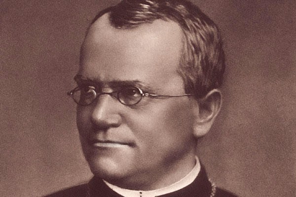
Gregor Johann Mendel (20 July 1822[1] – 6 January 1884) was a German-speaking Silesian[2][3] scientist and Augustinian friar who gained posthumous fame as the founder of the modern science of genetics. Though farmers had known for centuries that crossbreeding of animals and plants could favor certain desirable traits, Mendel's pea plant experiments conducted between 1856 and 1863 established many of the rules of heredity, now referred to as the laws of Mendelian inheritance.
Mendel worked with seven characteristics of pea plants: plant height, pod shape and color, seed shape and color, and flower position and color. With seed color, he showed that when a yellow pea and a green pea were bred together their offspring plant was always yellow. However, in the next generation of plants, the green peas reappeared at a ratio of 1:3. To explain this phenomenon, Mendel coined the terms “recessive” and “dominant” in reference to certain traits. (In the preceding example, green peas are recessive and yellow peas are dominant.) He published his work in 1866, demonstrating the actions of invisible “factors”—now called genes—in providing for visible traits in predictable ways.
The profound significance of Mendel's work was not recognized until the turn of the 20th century (more than three decades later) with the independent rediscovery of these laws.[4] Erich von Tschermak, Hugo de Vries, Carl Correns, and William Jasper Spillman independently verified several of Mendel's experimental findings, ushering in the modern age of genetics.

Biography

Johann Mendel was born into an ethnic German family in Heinzendorf bei Odrau, Moravian-Silesian border, Austrian Empire (now Hynčice, Czech Republic). (He was given the name Gregor when he joined the Augustinian friars.[5]) He was the son of Anton and Rosine (Schwirtlich) Mendel, and had one older sister, Veronika, and one younger, Theresia. They lived and worked on a farm which had been owned by the Mendel family for at least 130 years.[6] During his childhood, Mendel worked as a gardener and studied beekeeping. Later, as a young man, he attended gymnasium in Opava. He had to take four months off during his gymnasium studies due to illness. From 1840 to 1843, he studied practical and theoretical philosophy and physics at the University of Olomouc Faculty of Philosophy, taking another year off because of illness. He also struggled financially to pay for his studies and Theresia gave him her dowry. Later he helped support her three sons, two of whom became doctors. He became a friar because it enabled him to obtain an education without having to pay for it himself.[7]


Blaise Pascal

Blaise Pascal (French: [blɛz paskal]; 19 June 1623 – 19 August 1662) was a French mathematician, physicist, inventor, writer and Christian philosopher. He was a child prodigy who was educated by his father, a tax collector in Rouen. Pascal's earliest work was in the natural and applied sciences where he made important contributions to the study of fluids, and clarified the concepts of pressure and vacuum by generalizing the work of Evangelista Torricelli. Pascal also wrote in defense of the scientific method.
In 1642, while still a teenager, he started some pioneering work on calculating machines. After three years of effort and fifty prototypes,[1] he was one of the first two inventors of the mechanical calculator.[2][3] He built 20 of these machines (called Pascal's calculators and later Pascalines) in the following ten years.[4] Pascal was an important mathematician, helping create two major new areas of research: he wrote a significant treatise on the subject of projective geometry at the age of 16, and later corresponded with Pierre de Fermat on probability theory, strongly influencing the development of modern economics and social science. Following Galileo and Torricelli, in 1646, he refuted Aristotle's followers who insisted that nature abhors a vacuum. Pascal's results caused many disputes before being accepted.
In 1646, he and his sister Jacqueline identified with the religious movement within Catholicism known by its detractors as Jansenism.[5] His father died in 1651. Following a religious experience in late 1654, he began writing influential works on philosophy and theology. His two most famous works date from this period: the Lettres provinciales and the Pensées, the former set in the conflict between Jansenists and Jesuits. In that year, he also wrote an important treatise on the arithmetical triangle. Between 1658 and 1659 he wrote on the cycloid and its use in calculating the volume of solids.
Pascal had poor health, especially after his 18th year, and his death came just two months after his 39th birthday.[6]

james clerk maxwell

James Clerk Maxwell FRS FRSE (13 June 1831 – 5 November 1879) was a Scottish[2][3] mathematical physicist.[4] His most notable achievement was to formulate the classical theory of electromagnetic radiation, bringing together for the first time electricity, magnetism, and light as manifestations of the same phenomenon. Maxwell's equations for electromagnetism have been called the "second great unification in physics"[5] after the first one realised by Isaac Newton. James was also a dedicated Christian from his childhood and saw his science as a natural extension of his faith.[6]
With the publication of A Dynamical Theory of the Electromagnetic Field in 1865, Maxwell demonstrated that electric and magnetic fields travel through space as waves moving at the speed of light. Maxwell proposed that light is in fact undulations in the same medium that is the cause of electric and magnetic phenomena.[7] The unification of light and electrical phenomena led to the prediction of the existence of radio waves.
Maxwell helped develop the Maxwell–Boltzmann distribution, a statistical means of describing aspects of the kinetic theory of gases. He is also known for presenting the first durable colour photograph in 1861 and for his foundational work on analysing the rigidity of rod-and-joint frameworks (trusses) like those in many bridges.
His discoveries helped usher in the era of modern physics, laying the foundation for such fields as special relativity and quantum mechanics. Many physicists regard Maxwell as the 19th-century scientist having the greatest influence on 20th-century physics. His contributions to the science are considered by many to be of the same magnitude as those of Isaac Newton and Albert Einstein.[8] In the millennium poll—a survey of the 100 most prominent physicists—Maxwell was voted the third greatest physicist of all time, behind only Newton and Einstein.[9] On the centenary of Maxwell's birthday, Einstein himself described Maxwell's work as the "most profound and the most fruitful that physics has experienced since the time of Newton".[10]